Magic Earth Navigation & Maps
62.4M1,000,000+
Maps & Navigation
4.2

Magic Earth Navigation & Maps
Find the best route to your destination even without an internet connection. Magic Earth uses OpenStreetMap data and a powerful search engine to offer you the optimal routes for driving, biking, hiking and public transportation.
PRIVACY FIRST!
• We do not track you. We do not profile you. We do not trade in your personal data; moreover, we do not have it.
MAPS
• Save big on mobile internet costs and navigate reliably with offline maps powered by OpenStreetMap. 233 countries and regions are ready to be downloaded.
• Choose between 2D, 3D and Satellite map views.
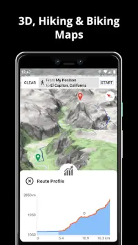
• Get ready for travel and know every detail of your route like surface, difficulty, distance and elevation profile.
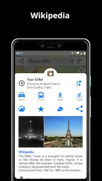
• Learn more about the points of interest near you from Wikipedia articles.
• Spot nearby parking places to easily park your car.
• Stay up-to-date and enjoy regular free map updates.
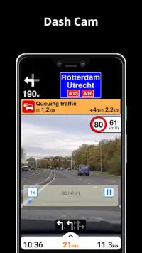
AI DASHCAM
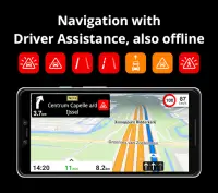
• Improve safe driving and avoid accidents. Receive alerts to potential problems on the road and record your trip.
• AI DashCam features Driver Assistance warnings and Dash Cam functionality.
• Avoid collisions and accidents with Driver Assistance warnings: Headway Warning, Forward Collision Warning, Pedestrian Collision Warning, Lane Departure Warning, Leaving Lane Warning, Stop & Go Assist.
• Record the road ahead during navigation to have an aid in the event of a collision or incident.
• Driver Assistance warnings and Recordings are available when the device is on a car mount in landscape mode, with a clear view of the road ahead.
* AI DashCam (with Driver Assistance warnings and Dash Cam functionality) requires Android 7 or later.
NAVIGATION
• Find the fastest or the shortest route to your destination when you travel by car, bike, on foot or with public transport.
• Plan your route with multiple waypoints.
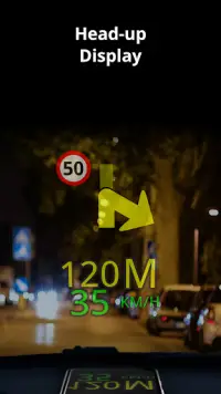
• Stay safe with the free Head-up Display (HUD) feature which projects the most important navigation info onto the windshield of your car.
• Know in advance which lane to take with precise turn-by-turn navigation and lane assistance.
• Get notified about speed cameras and stay up to date with current speed limits.
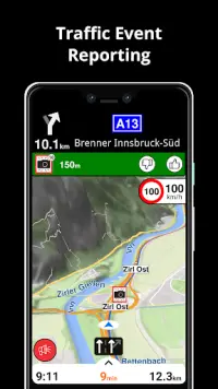
TRAFFIC INFO
• Get real-time traffic info, updated every minute.
• Discover alternative routes that avoid the traffic jams and save you time on the road.
PUBLIC TRANSPORT
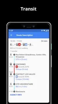
• Get around town quickly and easily. Choose from public transit routes that combine all transportation modes: bus / metro / subway / light rail / train / ferry
• Get walking directions, transfer times, departure times, number of stops. And when available, the cost.
• Find wheelchair or bike friendly public transportation.
WEATHER
• View current temperature and local weather forecast for your favorite locations.
• See what weather conditions to expect in the next hours and view the forecast for the next 14 days.
NOTES:
* Some features are not available in all countries.
* Some features require internet connection.
Show More
What's New
version 7.1.23.2.9B538E9E.0F5432B4
Bug fixes and stability improvements.
Information
- ID:com.generalmagic.magicearth
- Category:Maps & Navigation
- Updated:2022-10-25
- Version:7.1.23.2.9B538E9E.0F5432B4
- Requires:Android 4.1
- Available on:Google Play
- File size:62.4M